-
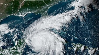
 The state’s property carriers are closely watching the progress of Hurricane Ian.
 -
The storm has sped up considerably over the past six hours.
-
Data from an Air Force Reserve Hurricane Hunter aircraft indicate the maximum sustained winds have increased to nearly 140 mph, the National Hurricane Center said.
-
The Category 3 hurricane is now expected to make landfall later today between Port Charlotte and Cape Coral/Fort Myers.
-
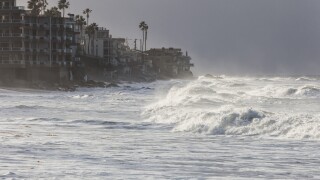
Storm surge may be felt in Tampa even if Ian does not land in the city.
-
Research by sister title Inside P&C shows the top three homeowners carrier exposures by county for forecast highest impact areas.
-
The dangerous storm is now projected to make landfall between Sarasota and Port Charlotte, Florida.
-
The storm is due to turn north-northeast and slow down after passing over Cuba today.
-
Hurricane Ian is expected to make landfall in Cuba today before moving through the south-eastern Gulf of Mexico into tomorrow.
-
The comps include 1896 (Category 3), 1921 (Category 3), 1944 (Category 2) and Hurricane Gladys in 1958 (Category 2).
-
A landfall at Category 3 or 4 along the west coast of Florida later this week would be one of the more damaging scenarios for Ian.
-
Cat 4 Hurricane Charley made landfall on Florida’s west coast in 2004, while Tarpon Springs (1921) was the last major storm to hit Tampa.